
Source files for San Diego Downtown homeless sleeper counts
sandiegodata.org-downtown_homeless-source-7.2.3. Modified 2024-11-26T06:18:18
Resources | Packages | Documentation| Contacts| References| Data Dictionary
Resources
- intersections_2019. Street intersections used for Ground Control Points, 2019
- intersections_2023. Street intersections used for Ground Control Points, 2023 update
- counts. Final homeless sleeper counts
- files. Final file annotations, including total counts, temperature and weather.
- gcp_transforms. Final ground control points and affine transformation matrices
- raw_count_annotations. Lightly processed count annotations
- raw_file_annotations. Lightly processed file annotations
- raw_gcp. Lightly processed Ground Control Points
Documentation
This dataset provides geographic locations for homeless sleepers in Downtown San Diego, as counted by enumerators from the Downtown San Diego Partnership. These counts have been done monthly since 2012, and this dataset provides counts since 2014.
This is the source package, use to generate analysis packages. Analysts should probably use one of the analysis packages. See the Data Library’s Homelessness Collection for all of the available datasets.
The count is done on paper maps with handwritten count marks. The San Diego Regional Data Library’s Downton Homelessness project converted these scanned count maps using a web based image annotation tool, VIA. These data are extracted from the JSON output from VIA.
This package has two top level files, and four predecessor files. The top level files are:
counts. One record for each handwritten count marking on a map.files. One record for each of the scanned, handmarked maps.
The predecessor files are:
raw_file_annotations. File annotations extracted from the VIA output.raw_count_annotations. Count annotations extracted from the VIA output.raw_gcp. Ground control point annotations ( street intersections ) extracted from VIA.gcp_transforms. Ground control points, in both image and geographic coordinates, with an affine transformation matrix to convert between them.intersections. Geographic positions and names of the street intersections used as ground control points.
Caveats
Because this data is extracted, manually, from manually recorded maps, there are a lot of quality issues.
Missing Months
Because of conversion errors and some complications with the source maps, there are several months of data that are excluded from this dataset
- August 2014. In the original datasets, August 2014 was a duplicate of September 2014.
- September 2014. Comfusion related to the duplication of September and August resulted in September being incompletely processed.
- June 2015. All of the map images for this month were blank. An alternate source PDF exists that is not blank, but this file was not used.
Not Using Ocupancy Multipliers
Since about 2017, HUD has instructed point-in-time homeless counts to multiply the counts of sleepers in structures and vehicles by factors to account for people who may be obsured and not directly countable. From April 2017 on, Downtown San Diego Partnership has been using these factors.
However, this dataset does not use the occupancy factors, to allow analysts to apply these factors consistently across all months of data. As a result, the counts from this dataset diverge from the official counts after March 2017.
Other Issues
- The
total_countoften does not match the sum of counts on the map. These sums were made by hand, by the enumerator who made the counts, so there are occasional arithmetic errors. - There are many instances of missing values for
rainortemp - Some dates include the day of the month, but many don’t These dates have a day of month of 1.
- Date day of month is generally unreliable. Only the year and month are reliable, except for files noted above.
- The
neighborhoodvalue is based on the map names, so in some months the East Village neighborhood is separated intoeast_villageandeast_village_south
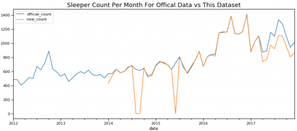
Comparison to Official Published Counts
This plot shows, per month, the offical published counts from San Diego Downtown Partnership versus the total from this dataset. Note the discrepancies dues to issues noted above, including missing months, minor differences in some months, and the divergence after March 2017 due to occupancy multipliers.
Versions
- Initial Release
- Remap some neighborhoods
- Map null neighborhood name ( ” ) to Gaslamp
- Fixed missing dates in Columbia, 2016, incorrect dates in Marina 2016, and other errors
- Excluded several months with quality problems, improved documentation
- Added column for source file, removed duplicated data form marina, 2016
- Added data for 2023 update.
Acknowledgements
The May 2023 update was done by researchers at the Homelessness Hub at UC San Diego:
- Zhongqi Zheng
- Daniel Sjoholm
- Yao Fu
The 2024 update was performed by:
- Zhongqi Zheng
- Daniel Sjoholm
- Michael Yang
- Patricia Estaris
- Lily Keefauver *
Documentation Links
Contacts
- Wrangler
- Origin
Data Dictionary
counts | files | raw_file_annotations | gcp_transforms | raw_gcp | raw_count_annotations | intersectionscounts
| Column Name | Data Type | Description |
|---|---|---|
| file_id | string | Link to files table |
| neighborhood | string | Neighborhood name |
| date | date | Date of the count, or the first of the month if the day of the date isn’t specified. |
| count | integer | Number of sleepers counted in the observation |
| type | string | “Individual”, “Structure” or “Vehicle” |
| x | number | Geographic X position, EPSG:2230, California State Plane 6 |
| y | number | Geographic Y position, EPSG:2230, California State Plane 6 |
files
| Column Name | Data Type | Description |
|---|---|---|
| image_url | string | Url to the original scanned, hand-marked map |
| file_id | string | Hash of image_url, to identify files. |
| source_file | string | Source file for the annotation data |
| url_year | integer | Year of the observation, from the URL to the image |
| url_month | integer | Month of the observation, from the URL of the image |
| date | date | Date of the observation, either from the annotation on the map, or from the URL. |
| neighborhood | string | Neighborhood name |
| url_neighborhood | string | Neighborhood name, from the URL |
| total_count | number | Total count for all sleepers. |
| temp | integer | Temperature, F |
| rain | string | Rain or clear |
raw_file_annotations
| Column Name | Data Type | Description |
|---|---|---|
| image_url | string | Url to the original scanned, hand-marked map |
| date | date | Date of the count, or the first of the month if the day of the date isn’t specified. |
| neighborhood | string | Neighborhood name |
| total_count | number | Total count for all sleepers. |
| temp | integer | Temperature, F |
| rain | string | Rain or clear |
| source_file | string | Source file for the annotation data |
gcp_transforms
| Column Name | Data Type | Description |
|---|---|---|
| url | string | Url to the original scanned, hand-marked map |
| neighborhood | string | Neighborhood name |
| source | string | The intersection polygon, formed from the intersection points, in WKT format, in the pixel coordinate space. This version is inverted from the coordinates of the image, with the Y coordinate being subtracted from 2000, so the orientation of the Y axis is the same as the EPSG:2230 geographic coordinate space. |
| dest | string | The intersection polygon, but in EPSG:2230 (State plane 6, California, Feet) coordinates. |
| matrix | string | An affine transformation matrix that transforms from the coordinates of source_inv to dest. When pixel locations are properly inverted, this matrix transforms from pixel locations to geographic locations. |
raw_gcp
| Column Name | Data Type | Description |
|---|---|---|
| image_url | string | Url to the original scanned, hand-marked map |
| x | integer | X position of upper left of region rectangle, in pixels |
| y | integer | Y position of upper left of region rectangle, in pixels |
| width | integer | Width of selection region rectangle in pixels |
| height | integer | Height of selection region rectangle in pixels |
| intersection | string | Name of intersection |
raw_count_annotations
| Column Name | Data Type | Description |
|---|---|---|
| image_url | string | Url to the original scanned, hand-marked map |
| cx | integer | X value of the center of the circle region, in pixels |
| cy | integer | Y value of the center of the circle region in pixels |
| r | number | Radius of the circle region, in pixels |
| type | string | Type of sleeper: Individual, Vehicle or Structure |
| count | integer | Count of sleepers |
intersections
| Column Name | Data Type | Description |
|---|---|---|
| geometry | string | Point position of center of intersection, EPSG:2230, California State Plane 6 |
| neighborhood | string | Neighborhood name |
| intersection | string | Intersection name |
References
Urls used in the creation of this data package.
- data/2019. Source directory for 2019 files
- data/2023/SDDT_102923/output. Source directory for 2023 files
Packages
- s3 s3://library.metatab.org/sandiegodata.org-downtown_homeless-source-7.2.3.csv
- csv https://library.metatab.org/sandiegodata.org-downtown_homeless-source-7.2.3.csv
- source https://github.com/metatab-packages/sandiegodata.org-downtown_homeless-source.git
Accessing Data in Vanilla Pandas
import pandas as pd


intersections_2019_df =  pd.read_csv('https://library.metatab.org/sandiegodata.org-downtown_homeless-source-7.2.3/data/intersections_2019.csv')
intersections_2023_df =  pd.read_csv('https://library.metatab.org/sandiegodata.org-downtown_homeless-source-7.2.3/data/intersections_2023.csv')
counts_df =  pd.read_csv('https://library.metatab.org/sandiegodata.org-downtown_homeless-source-7.2.3/data/counts.csv')
files_df =  pd.read_csv('https://library.metatab.org/sandiegodata.org-downtown_homeless-source-7.2.3/data/files.csv')
gcp_transforms_df =  pd.read_csv('https://library.metatab.org/sandiegodata.org-downtown_homeless-source-7.2.3/data/gcp_transforms.csv')
raw_count_annotations_df =  pd.read_csv('https://library.metatab.org/sandiegodata.org-downtown_homeless-source-7.2.3/data/raw_count_annotations.csv')
raw_file_annotations_df =  pd.read_csv('https://library.metatab.org/sandiegodata.org-downtown_homeless-source-7.2.3/data/raw_file_annotations.csv')
raw_gcp_df =  pd.read_csv('https://library.metatab.org/sandiegodata.org-downtown_homeless-source-7.2.3/data/raw_gcp.csv')
Accessing Package in Metapack
import metapack as mp
pkg = mp.open_package('https://library.metatab.org/sandiegodata.org-downtown_homeless-source-7.2.3.csv')

# Create Dataframes
intersections_2019_gdf = pkg.resource('intersections_2019').geoframe()
intersections_2023_gdf = pkg.resource('intersections_2023').geoframe()
counts_df = pkg.resource('counts').dataframe()
files_df = pkg.resource('files').dataframe()
gcp_transforms_df = pkg.resource('gcp_transforms').dataframe()
raw_count_annotations_df = pkg.resource('raw_count_annotations').dataframe()
raw_file_annotations_df = pkg.resource('raw_file_annotations').dataframe()
raw_gcp_df = pkg.resource('raw_gcp').dataframe()